Monday, May 22, 2024

Agricultural Drones for Precision Farming: Key Field Uses and Limits
by
Published
Views:
Agricultural drones for precision farming are reshaping field intelligence across modern agriculture and adjacent industrial systems.
They support faster crop observation, targeted treatment, and better timing across scouting, mapping, and input application workflows.
Their growing relevance extends beyond farms into data benchmarking, equipment planning, environmental compliance, and cross-sector operational analysis.
Still, agricultural drones for precision farming are not universal solutions.
Battery endurance, payload capacity, weather sensitivity, pilot rules, and data interpretation limits directly affect real-world performance.
A practical evaluation must balance agronomic benefit with technical constraints, workflow integration, and measurable return.
Core Definition and Operating Scope
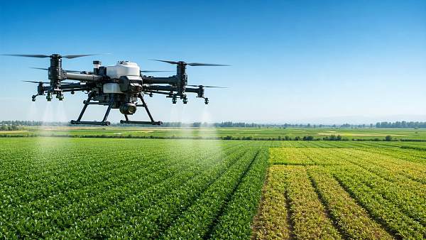
Agricultural drones for precision farming are unmanned aerial systems used to collect, process, or act on field-level data.
They usually combine airframes, navigation modules, sensors, control software, and analytics platforms.
Some models focus on imaging.
Others are designed for spraying, seeding, or limited material distribution.
In precision agriculture, their purpose is not simple aerial viewing.
Their value lies in capturing spatial variability and linking that variability to decisions.
This includes identifying stress zones, checking stand establishment, verifying drainage behavior, and documenting treatment results.
The best outcomes appear when drone data connects with ground truth, machinery records, and seasonal management plans.
Main system categories
- Multirotor drones for short-range scouting and precise low-speed operations.
- Fixed-wing drones for larger-area mapping and longer flight paths.
- Hybrid platforms balancing endurance with takeoff flexibility.
- Spray drones built around tanks, pumps, nozzles, and flow control.
Industry Context and Current Attention Areas
Interest in agricultural drones for precision farming has expanded as agriculture becomes more data-driven and resource-constrained.
Rising input costs, climate variability, labor shortages, and traceability demands have accelerated adoption.
At the same time, drone capability now intersects with electronics, batteries, software, environmental reporting, and smart machinery ecosystems.
This makes the topic relevant within a broader industrial framework, not only within crop production.
For intelligence platforms such as GIM, these signals matter because drone deployment affects component sourcing, software validation, and benchmarkable field performance.
Key Field Uses of Agricultural Drones for Precision Farming
The strongest use cases for agricultural drones for precision farming are those where field variation is visible, time-sensitive, and economically important.
1. Crop scouting and stress detection
Drones quickly reveal uneven emergence, lodging, nutrient deficiency, waterlogging, and heat stress.
Compared with walking fields alone, coverage is faster and more spatially consistent.
2. Weed, pest, and disease monitoring
High-resolution imaging can isolate patch infestations before they spread across the entire field.
This supports selective intervention rather than blanket treatment.
3. Stand counts and establishment checks
Early-season flights help verify planting quality, row uniformity, and replant decisions.
That is especially useful in high-value crops or large planting windows.
4. Terrain, drainage, and variability mapping
Elevation models and orthomosaics can highlight runoff paths, erosion risk, and persistent wet spots.
These maps guide drainage improvements and zone-based management.
5. Targeted spraying
Spray drones can treat inaccessible areas, wet fields, steep terrain, and localized outbreaks.
They reduce crop trampling compared with ground equipment in selected situations.
6. Documentation and verification
Repeated flights create visual records for agronomic review, insurance support, and sustainability reporting.
Business Value Across a Broader Industrial Landscape
Agricultural drones for precision farming create value when they shorten decision cycles and improve action quality.
The benefit is rarely the image alone.
The benefit comes from better timing, more precise intervention, and clearer performance measurement.
- Lower scouting time across dispersed acreage.
- Earlier detection of issues that would otherwise reduce yield or quality.
- More selective use of chemicals and operational passes.
- Improved digital traceability for audits and performance reviews.
- Better alignment between field events and machinery scheduling.
Within integrated industrial analysis, drones also generate demand for batteries, sensors, edge computing, connectivity, and software interoperability.
That makes them relevant for technical benchmarking across several supply chain layers.
Typical Scenarios and Technology Matching
Main Limits and Deployment Risks
Understanding limits is essential before investing in agricultural drones for precision farming.
The most common constraints are technical, regulatory, and operational.
Battery life and field coverage
Flight time often declines with wind, payload, and temperature.
Large fields may require multiple battery sets and careful route planning.
Payload and application limits
Spray drones cannot match the tank capacity of self-propelled ground sprayers or aircraft.
They fit niche or targeted use better than broadacre replacement.
Weather sensitivity
Wind, rain, humidity, and unstable light conditions affect stability, drift, and image quality.
Regulatory compliance
Rules vary by market and may cover pilot certification, visual line of sight, altitude, and chemical application permits.
Data quality and interpretation
Poor calibration or weak analytics can produce misleading conclusions.
A colorful map is not automatically an actionable prescription.
Integration burden
If outputs do not connect with farm software, GIS layers, or equipment systems, value remains isolated.
Practical Evaluation and Implementation Guidance
A disciplined rollout reduces disappointment and improves measurable return from agricultural drones for precision farming.
- Start with one defined problem, such as drainage mapping or hotspot scouting.
- Match platform type to acreage, terrain, and desired output.
- Verify sensor quality, calibration method, and software compatibility.
- Estimate battery, refill, transport, and processing requirements before field season.
- Confirm airspace and application rules in each operating region.
- Use ground checks to validate image-based conclusions.
- Track outcomes against cost, response speed, and treatment accuracy.
This approach aligns well with cross-sector benchmarking logic.
It turns a promising tool into a measurable operational asset.
Next-Step Perspective
Agricultural drones for precision farming offer clear advantages in visibility, targeting, and response speed when matched to the right field tasks.
They are most effective when supported by sound data practices, realistic coverage expectations, and integration with wider technical systems.
For organizations comparing smart agri-tech options, the next step is simple.
Map the intended use case, define success metrics, and benchmark drone capability against field conditions, compliance requirements, and digital infrastructure.
That is where agricultural drones for precision farming move from interest to dependable value.
The Archive Newsletter
Critical industrial intelligence delivered every Tuesday. Peer-reviewed summaries of the week's most impactful logistics and market shifts.